The first in our series of Brighton Area Guides where we bring you the lowdown on each area of the city. A local takes you on a journey through their neighbourhood unveiling the hidden gems, interviewing other locals and divulging their favourite stops for day trippers and Brightonians alike.
An Insider’s Guide To
The North Laine
“A visit to Brighton comprised every possibility of future happiness”
Jane Austen, Pride and Prejudice
What’s the difference between the lanes and laines? 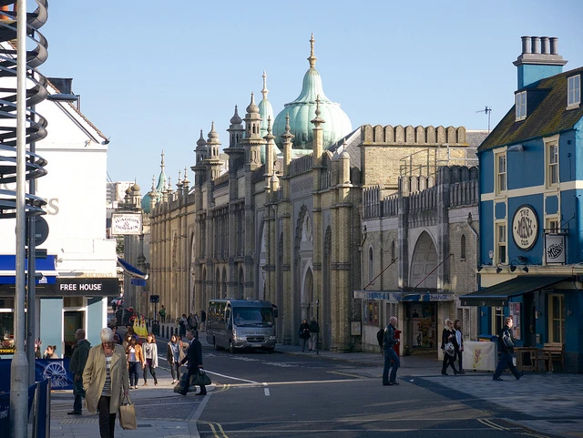
In case there’s anyone out there who’s a bit cloudy on the difference, here’s an overview:
The lanes are the quaint little passageways that lie between North Street, East Street and Ship Street. This, according to ‘Brighton; A Very Peculiar History’ is the oldest part of our beloved city. What used to be a fisherman’s hang-out is now host to some of Brighton’s best bars, eateries and shops. If you stroll along the lanes at night, pretty fairy lights dot the alleyways. As if you had woken up in Neverland. This effect is all the more powerful after a few drinks!
The Laines, however, refer to a different area. During Medieval times, the surrounding downs and fields were divided into five Laines: North, West, East, Little and Hilly. The North Laine, our current area of focus, sits in that special place between the railway station and North Street.
We may as well begin our journey at the station.
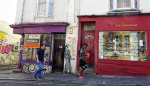
Once the barriers have consumed your ticket, exit right and curve around, walking under the bridge and downhill into Trafalgar Street. Banksy has been known to make an appearance along this stretch and a famous piece of his, adorning The Prince Albert pub, was removed and sold recently; even minus a Banksy, the surrounding brickwork is usually donned with impressive graffiti art.
Half-way down this strip, you’ll find a gem of a café. HelmSton, described as serving “friendly folk food”, is a delight. The food is delicious; fresh and healthy, as well as being vegan / veggie. Also catering for dietary requirements!
Turning south into Sydney Street, you’ll be graced with an abundance of vintage markets and leather shops.
“There’s no other place I’d rather be based than the North Laine; the creative vibes here are like nowhere else,” commented Posh Totty’s Alice Rivers Cripps as I scouted around her original hand-stamped, personalised jewellery shop. “There are so many independent shops and this really draws people in. It’s such a great curation of independent design and I think shoppers really value that. Brighton is a creative town, full of makers.”
Once you’ve shopped yourself silly, refuel on a snack at the Flour Pot Bakery. You’ll barely have to move between the two; my kind of indulgence!
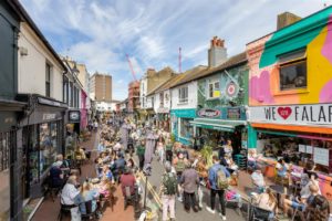
Next stop Kensington Gardens.

“There such a great selection of vintage clothing in Brighton and the real epicentre of all this is the North Laine, where the vintage scene is thriving,” said former vintage clothing business owner Molly Bray. “It’s a joy to have such a wonderful community of customers and neighbours, who share my love of vintage, right on my doorstep! The incredible variety of independent, creative businesses is what keeps the North Laine such an exciting and unusual area.”
There are vintage shops a’plenty in this part of town. Beyond Retro usually gets its fair share of attention (as well it should; it’s wicked) but definitely check out the smaller stores, like All About Aud in Trafalgar.
If you end up in Kensington Gardens; it’s always rammed so be prepared. This street is home to some truly wonderful eateries: Iydea and Wai Kika Moo Kau being two of the most yummy veggie joints my taste-buds have ever had the pleasure of experiencing. Try the tofu in Wai Kika! As a fully-fledged meat-eater, I was hesitant but the friendly waiter said he’d refund me if I didn’t like it… Lo and behold, he kept the money.
“Prior to moving to Brighton two years ago, you’d NEVER see me in a veggie or vegan café. How things have changed… “
It’s along this stretch that you’ll also find the famous Snoopers Paradise; well worth hunting through for anything and everything, and make sure you dress up and take a pic of yourselves in the photo booth!
Just down from Snoopers is Resident Records, in my opinion Brighton’s best music shop These guys also sell tickets to live music gigs in and around Brighton.
“Brighton is the perfect place to visit for a spot of record shopping as we are lucky enough to still have a wealth of record shops, selling both new and second hand,” said Resident’s Natasha Youngs. “We are amongst a whole host of independent, interesting & individual businesses who collectively make Brighton a really exciting & vibrant place to shop”.
At the end of Kensington, you’ll see Brighton’s much-loved Infinity Foods: the UK’s leading wholesale distributors of organic and natural foods. If you’ve spent your life avoiding the kitchen (like me), then you’ll be amazed at the array of veg in there. I’ve been introduced to vegetables I never knew existed. Infinity: a whole new world. Shining, shimmering, splendid.
Parallel to Kensington Gardens is Upper Gardner Street.

This is quieter than its neighbour and the street is lined with independent markets and stalls. All the furniture is upcycled and they enforce a zero waste policy. If that isn’t hip enough for you, the menu of this truly sustainable food business is exquisite. I practically dribbled over my dish.
Mosey on over to Gardner street.

Here you can enjoy the pleasure of making friends with Rolf from the Muppets – Rolf is a master pianist and he also gives out free hugs. What else do you need in life?
In Gardner, you’ll also be serenaded by bird-song as (in)famous local Tim Bat aka Birdyman walks around selling bird whistles, and at the far side of the street there’s usually a live band / musical duo.
This street is also home to Komedia; Brighton’s premier live entertainment venue presents one of the largest, most diverse arts and entertainment programmes in the UK. “We love our home in the centre of the North Laine,” said Emily Coleman from Komedia. “It’s the perfect location, as well a friendly, welcoming and vibrant… a lot like us!”
Finally, it’s well worth mentioning the arts and culture hotspot, situated towards the end of the North Laine.

Photograph taken by Simon Dack
If you haven’t visited the Royal Pavilion, then you haven’t lived… in Brighton. As a theatre buff, I’d also recommend you catch a show at the 208 year old Theatre Royal Brighton. As well as being recognised as the South Coast’s premiere venue, this is one of the oldest working theatres in the country.
In summary: Brighton’s North Laine is home to many creative creatures – musicians, artists, independent businesses and the residents themselves. The people in this part of town are so friendly; smiles will greet you left, right and centre! Visit the North Laine and you’ll have your pick of delicious cafes, cosy pubs, bustling bars, quirky shops and hotspots. There’s something for everyone in this part of town.
Some useful links
A slice of history: wikipedia.org/North_Laine
The incredible story of how North Laine got it’s name: mybrightonandhove.org.uk
Places to stay: stayintheheartofbrighton.com / brightonholidaylets.com
For general tourist information about Brighton: tourism.brighton.co.uk / visitbrighton.com